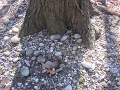
 Smooth cobbles found on some dry hilltops in Rock Creek Park are thought to have been deposited by the ancestral Potomac River.
Photographer: Rod Simmons, courtesy of NPS
Since water follows gravity, rivers are found in low areas of the landscape. Yet some of the highest ridges in and adjacent to Rock Creek Park are capped with remnants of ancient river gravel terraces up to 30 feet thick.
The soil surface in such places is commonly very stony, marked by smooth pebbles and cobbles of quartz and sandstone that were rounded and polished by running water long ago. These pre-historic river terraces are thought to have been deposited in channels of the ancestral Potomac River migrating over a wide floodplain as it flowed toward the nearby coastline. The ancient river gravels are believed to have been deposited over a period of time, forming several nearly continuous layers, each at a different elevation, which once blanketed the entire Washington region.
Why are river deposits now found on Rock Creek Park’s highest ridgetops? After these ancient terraces were deposited, the entire landscape was subsequently uplifted, tilted to the southeast, and then deeply dissected by water as intensive erosion carved the modern Rock Creek valley during the Ice Age.
To the west of the Fall Zone, this left only a few irregular patches of gravel on top of the higher Piedmont uplands. A somewhat thicker and more widespread set of these gravelly pre-historic river terraces bounds the east rim of Rock Creek valley, including the outlying Fort Circle Parks area to the northeast (Fort Stevens, Fort Totten, Fort Slocum, Fort Bunker Hill).
By virtue of their elevation, these gravelly hilltops were a natural choice for siting many of the Rock Creek area’s 16 Civil War forts. Tip: To see the location of the forts closest to Rock Creek, search for "fort" on the Rock Creek Park Map Viewer.
Tip: You can find ancient river gravel and sand terrace deposits on the Rock Creek Park Map Viewer. On the right, click Natural Features, then select the map layer Surficial Geology. You'll need to hide Natural Communities and Ecological Systems to see it. Use the slider bar to display different kinds of information about this layer. Look at the Legend to find Terrace deposits and Potomac Formation - sand-dominated lithofacies.